Key facts that make the hike easier to plan
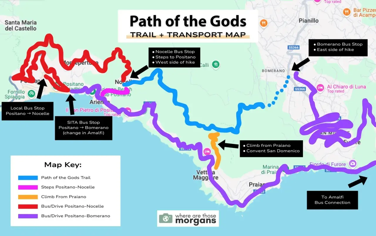
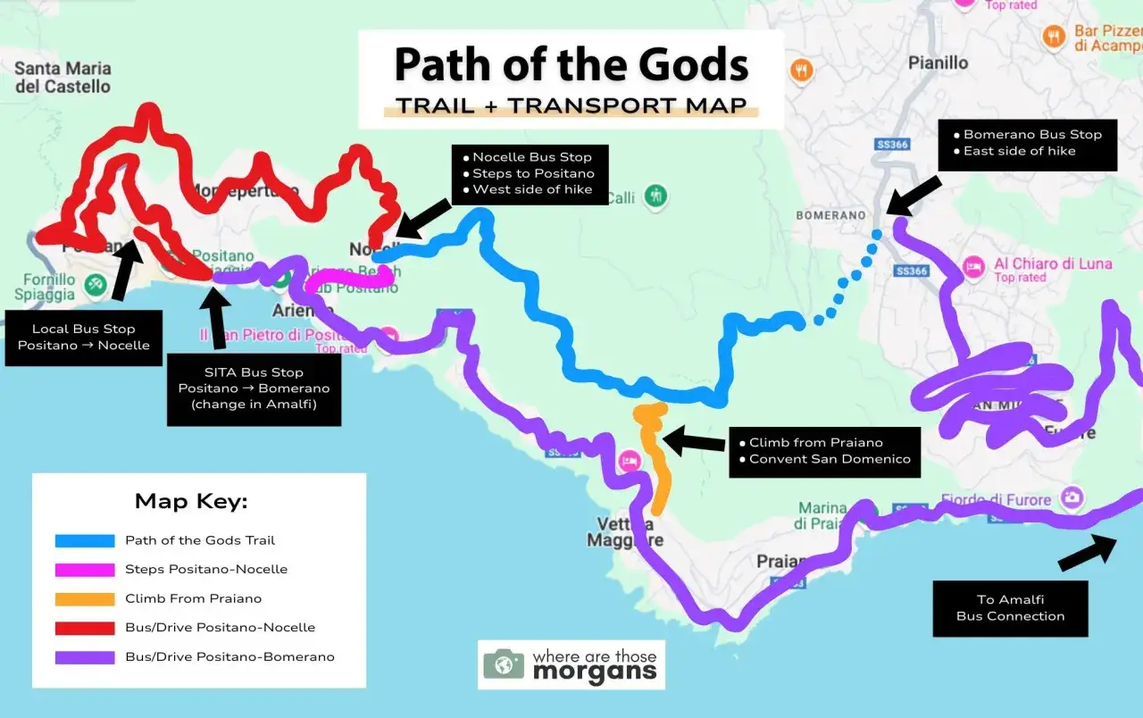
- The main route runs from Bomerano in Agerola to Nocelle above Positano, and that is the direction I would choose first.
- The official trail is about 5.3 km and usually takes around 2 hours for strong walkers, longer once you add stops and the descent into Positano.
- The trail is classed as an E route, which means it is a hiking path rather than a technical climb, but it still demands decent fitness and sure footing.
- At Colle La Serra, the route splits: the left branch is more exposed and scenic, while the 327a variation is a better choice if you dislike narrow edges or dizziness.
- The biggest planning mistake is treating Nocelle as the finish line and forgetting that Positano still sits far below it, reached by a long stair descent.
- Bring offline navigation, water, sun protection, and a realistic transport plan for both the start and the end of the hike.
How the trail is laid out
The route is compact, but it is not flat in the way many first-time visitors assume. On the official Monti Lattari trail listing, the Path of the Gods is trail 327, starting in Piazza P. Capasso in Bomerano and ending in Nocelle above Positano. That gives you a useful mental model right away: this is a point-to-point hike across the ridge, not a loop, and the best maps should show the trailhead, the key junctions, and the final village connection clearly.
What I look for on the map is less about decoration and more about decision points. The important markers are Bomerano, Grotta Biscotto, Colle La Serra, the 327a split, and Nocelle. The official route is short on paper, but the terrain changes feel more substantial because of the exposed sections, stair steps, and constant sightline to the coast. That is exactly why a clean route map matters here: it helps you understand where the trail is straightforward and where it becomes more demanding.
| Route fact | Practical meaning |
|---|---|
| Length | About 5.3 km on the official trail |
| Time | Around 2 hours on the official listing, usually longer with photo stops |
| Elevation profile | Mostly downhill from Bomerano to Nocelle, with some short climbs |
| Difficulty | E grade, so non-technical but still a real hike |
| Best use of the map | Check junctions, side variants, and the connection to Positano before you start |
That gives you the structure of the hike itself, which makes the next question obvious: which direction actually works best in real life?
Which direction works best in real life
I would start in Bomerano almost every time. It keeps the hike in its most natural rhythm, with the sea ahead of you and the trail gradually unfolding underfoot. More importantly, it lets you use the long descent in your favor instead of fighting it on tired legs. The reverse direction is possible, but it asks more from your knees, your balance, and your patience.
| Direction | Best for | Main advantage | Main drawback |
|---|---|---|---|
| Bomerano to Nocelle | Most hikers | Best balance of views and effort | You still need a separate plan to reach Positano |
| Nocelle to Bomerano | Strong hikers who want a different challenge | Useful if your lodging is above Positano | Harder on the legs and less intuitive for first-timers |
| Praiano access | Travelers staying in Praiano | Convenient if you want to build the hike around your base | Steep stair approaches can be more punishing than people expect |
The most common mistake is assuming the map’s end point and your day’s finish point are the same thing. They are not. Nocelle is above Positano, which means the trail technically ends before the long staircase down to town begins. If you are hoping for a gentle coastal stroll straight into Positano, the route will correct that expectation fast. From here, the more useful question is what the map does not show clearly enough at first glance.
What the map does not show at first glance
On a screen, the hike looks tidy. In person, several practical details matter much more than the line itself. The first is exposure: large sections are open to sun and wind, so midday heat can make an otherwise moderate hike feel much tougher. The second is footing: even when the route is well marked, it includes uneven stone, gravel, and short stair segments that punish weak shoes and distracted walkers.
There is also a small but important fork at Colle La Serra. The left branch is the more dramatic one, with broader views and a slightly more exposed feel. The 327a variation is the calmer option if you want something less airy or you know you are uneasy near cliff edges. I think that distinction is one of the most useful things a good trail map should show, because it is not just a navigation choice; it is a comfort choice.
- Water is limited, so I would not rely on casual refills as your main hydration plan.
- Sun exposure is real, especially from late spring through early autumn.
- Offline navigation helps, even on a well-signed trail, because junctions and side paths can still create hesitation.
- The final descent is separate from the official trail and should be treated as its own effort.
- Weather changes the experience quickly, especially when the ridge is windy or the limestone surface is wet.
The CAI listing marks water points at Bomerano, Colle La Serra, and Nocelle, but I still plan as if I will not want to depend on them. That kind of caution sounds minor until you are halfway across the ridge in heat and realize you underestimated how much water you need. Once you know how the terrain behaves, the next bottleneck is getting to the trailhead and back without turning the day into a transfer puzzle.
How to get there and get back without losing half the day
Transportation is the part most hikers underestimate. The official trail begins in Bomerano, which you can reach by car or by the SITA bus line connecting Amalfi and Agerola. That is workable, but it is not friction-free if you are staying on the coast and trying to fit the hike into a single day. For a lot of travelers, the map is the easy part; the bus connections are what eat the time.
| Transport option | Why it works | Why it fails | My take |
|---|---|---|---|
| Public bus to Bomerano | Lowest-cost option and closest to the trailhead | Timing can be awkward and transfers add stress | Fine if you are flexible and start early |
| Private transfer | Fast, predictable, and easy to coordinate | Costs more than public transport | Best choice if you value time over savings |
| Organized hike with transfer | Removes the logistics problem completely | Less independent and usually pricier than DIY | Most practical for a one-day Amalfi Coast itinerary |
| Return from Positano by ferry or bus | Lets you end the day in a scenic town | Schedules can be affected by weather and crowds | Good if you already planned Positano as part of the day |
If I were building the day from scratch, I would start early, get to Bomerano before the heat peaks, and decide my return transport before I leave my accommodation. That sounds basic, but it is the difference between a smooth hike and a long, tired day of guessing. Once that is settled, the last thing to get right is what you carry with you.
What I would pack for this trail
The hike is short enough that some travelers treat it casually, and that is exactly where mistakes creep in. I would pack for sun, footing, and time on exposed terrain rather than for a technical mountain expedition. The essentials are simple, but they matter more here than they do on a shaded woodland trail.
- Trail shoes or grippy trainers with enough traction for gravel and stone steps.
- At least 1.5 liters of water per person, and closer to 2 liters in warm months.
- Sun protection, including a hat, sunglasses, and sunscreen.
- Offline map data, even if you trust the signage.
- Light snacks such as fruit, nuts, or a sandwich, because this is not a place to rely on finding food at every turn.
- Trekking poles if your knees dislike long descents, especially if you plan to continue down into Positano.
- Cash for small purchases, buses, or a quick stop in a village cafe.
I also recommend starting earlier than feels necessary. A ridge walk with no shade feels very different at 8:30 a.m. than it does at noon, and the earlier start usually means fewer people in the narrow sections. That single timing choice improves both comfort and photography, which is rare on a route this popular.
The small details that make the day easier on the ground
The route itself is famous for a reason: the views are exceptional, the trail is manageable for many hikers, and the coastal setting is one of the most dramatic in Europe. But the best experience comes from treating it as a planned mountain day, not an impulsive scenic walk. Know where the official trail starts, choose the Bomerano-to-Nocelle direction, allow for the stairs into Positano if that is part of your day, and carry enough water and time to enjoy the walk instead of rushing it.
If you keep those pieces aligned, the map stops being just a reference and becomes a useful decision tool. That is the version of this hike I would want before stepping onto the ridge: simple, readable, and honest about the effort it asks for.