The Pyrenean High Route is one of Europe’s most demanding long-distance mountain traverses, and the haute route pyrenees earns its reputation through remoteness, constant climbing, and route-finding that keeps you alert from the first week to the last. This guide breaks down what the route actually is, how hard it feels in real life, when to go, how to handle food and sleep, and what I would pack before committing to it.
Key facts that shape the whole hike
- The HRP runs from Hendaye on the Atlantic to Banyuls-sur-Mer on the Mediterranean, usually in the 750-800 km range depending on variations.
- It is not a single officially marked trail, so navigation is part of the challenge, not an occasional nuisance.
- Most fit hikers need roughly 35-45 hiking days, with extra time if they want rest days or weather margins.
- The best window is usually mid-July through September, but June can still hold serious snow and September can turn colder fast.
- Compared with the GR10 and GR11, the HRP is the most committing option: higher, rougher, and much less signposted.
- Bivouac is often possible, refuges are useful, and resupply gaps can be long enough to matter.
What the Pyrenean High Route actually is
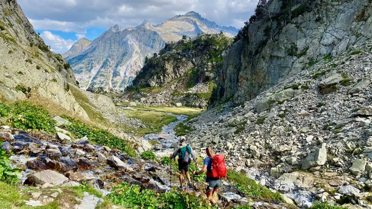
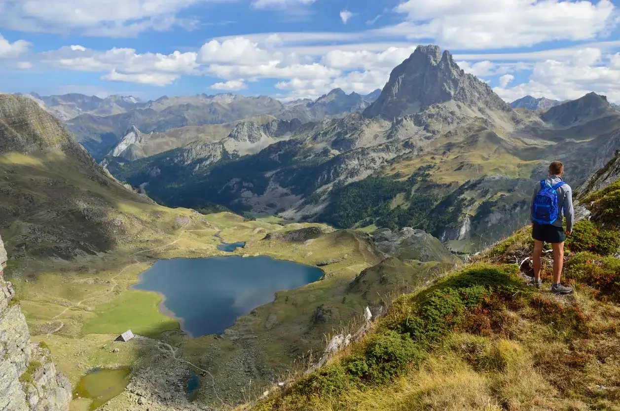
The HRP is a high mountain traverse that shadows the France-Spain border and slips through Andorra before finishing at the Mediterranean. I think of it less as a single trail and more as a route system: a stitched-together line of paths, ridge walks, valley exits, and occasional alternatives that stay as high as conditions allow. That flexibility is part of the appeal, but it also means there is no one fixed experience and no simple “follow the blazes” approach.
In practice, that makes the route feel more personal than a standard long trail. One hiker may stay close to the crest whenever possible; another may choose lower alternatives when snow, storms, or fatigue make the higher line unwise. Either way, the landscape stays serious: big passes, long descents, and a steady sense that you are moving through genuine mountain country rather than a curated walking corridor.
For me, that is the main distinction. The HRP is not about comfort or easy logistics. It is about committing to the Pyrenees at their most elevated and remote, then accepting that the route will ask you to adapt as the mountains change around you. That becomes much more obvious once you compare it with the better-known Pyrenean crossings.
How the HRP compares with the GR10 and GR11
| Route | Navigation | Terrain feel | Best for |
|---|---|---|---|
| HRP | Mostly unmarked, with route choice and map reading required | Highest, roughest, and most committing | Experienced hikers who want the toughest and wildest line |
| GR10 | Well waymarked throughout | More valley-oriented and generally easier to follow | First Pyrenean thru-hike, or anyone prioritizing clarity and support |
| GR11 | Well waymarked throughout | Rougher and higher than the GR10, but still easier to follow than the HRP | Strong hikers who want challenge without self-navigation for every stage |
The practical difference is simple: on the GR10 or GR11, the path usually tells you where to go. On the HRP, you have to tell the path where to go. That means map skills, terrain judgment, and weather awareness matter much more than they do on the signed alternatives. The payoff is a route that often feels more direct, more alpine, and more solitary, but I would not recommend it as a first long-distance mountain walk unless you already know how you handle rough ground, uncertainty, and long days.
That leads straight into the most important planning question of all: when do the mountains actually cooperate?
When to go and how weather changes the route
If I were planning the HRP for a typical year, I would treat mid-July to early September as the safest planning window. June can still hold meaningful snow in the high Pyrenees, and some sections may need an ice axe and crampons well into the second week of the month. By July, many snowfields shrink to patches, but that does not mean the route becomes trivial; a few stubborn crossings can still demand traction depending on the year.
July and August are also the warmest months, which sounds pleasant until you hit the eastern end of the range and the Mediterranean heat starts to bite. Afternoon thunderstorms are common through the summer, and they can turn a stable morning into a miserable or dangerous afternoon very quickly. I would plan my day around that pattern: start early, move efficiently, and avoid pretending the weather will wait for me.
September has its own logic. Crowds thin out, temperatures become more comfortable for climbing, and the mountains often feel calmer. The trade-off is obvious: colder nights, more overnight frost, and a higher chance that early snow shows up again. If you are comfortable managing risk and you want cooler conditions, September can be excellent. If you want the least technical version of the trail, a solid mid-summer start is usually better. Either way, the route becomes much easier to enjoy once you think in terms of weather windows rather than calendar dates.
How to plan stages, food, and sleep without overcomplicating it
The current guidebook breaks the traverse into 44 stages, which is useful as a planning backbone even if you do not follow it exactly. Some stages are short, some are punishing, and fit hikers often combine or split them based on weather, energy, and where they can sleep. In realistic terms, I would expect 35-45 hiking days for a strong thru-hike, then add rest days and weather days on top of that if you want the trip to feel sane rather than compressed.
Food planning matters more here than on many long trails because the resupply rhythm is uneven. There are villages and towns along the way, but there are also stretches where you need to carry several days of food, and one particularly awkward gap after Salardu can run to about 6-9 days before the next easy resupply at L’Hospitalet-près-l’Andorre if you do not divert. Tavascan is an optional stop after roughly 2-3 days, but the shop there is small enough that I would not treat it as a full reset unless I had to.
I would also keep accommodation flexible. Bivouac works over much of the route, but the rules vary by country and by protected area, and some parks impose time limits on when you can pitch. Staffed refuges make the hike much easier to manage, but summer beds can fill up and they are not cheap. A useful planning figure is about €40-50 for a refuge bed before meals, with food extra, though you should expect this to vary by season and location.
For that reason, I would not build the whole trip around last-minute improvisation. Book the places you know you need, keep your food carries honest, and leave room in the schedule for one weather pause every week or so. That kind of margin saves more hikes than extra fitness does.
What I would pack before I trusted the route
I would pack the HRP like a serious mountain trip, not a casual summer trek. The route rewards lightness, but not at the expense of the essentials. If I were camping often, I would want a pack in the 40-50L range; if I were using refuges most nights, 30-35L could work. The exact volume matters less than whether the pack can handle food carries, a warm layer, and an occasional snow kit without becoming awkward.
- Navigation: offline maps, paper maps, compass, and a GPX track on a phone or GPS unit.
- Traction: microspikes or light crampons if you start early in the season or expect lingering snowfields.
- Water capacity: enough to carry 2-3L, because some sections are dry.
- Water treatment: a filter or purification method for streams and pools.
- Weather protection: shell layer, warm midlayer, hat, gloves, and sun protection.
- Sleep system: whatever works for your comfort level, but keep it realistic for cold mountain nights.
- Cash and ID: useful for refuges, small shops, and places that do not want a card transaction for everything.
My strongest piece of advice is simple: do not try to save weight by cutting the wrong things. I would rather carry a slightly heavier pack with navigation margin, water capacity, and a proper weather layer than gamble on “fast and light” while crossing high passes in unstable conditions. On this route, the penalty for being underprepared is much larger than the penalty for carrying a few extra grams.
That practical mindset also helps you make better route choices once you are actually moving.
The choices that make the trek easier or harder
Direction matters more than many first-timers expect. Eastbound from Hendaye to Banyuls-sur-Mer is the more common choice, and I think it makes intuitive sense because the route builds naturally from the Atlantic side into the higher central mountains before easing toward the Mediterranean. Westbound works too, but it can feel less standard when you are trying to line up transport, weather, and your own pacing.
The other big choice is how closely you want to stick to the high line. The HRP is famous for optional variations, and that is not just a detail for map nerds. A low alternative can be the right call in bad weather, but if you always choose the easier bypass, you lose the very character that makes the route special. I would use alternates deliberately, not reflexively.
There are also a few optional peaks that can turn a long traverse into something more memorable. Summits such as Vignemale, Taillon, and Aneto are common add-ons, and they can be excellent if the weather is stable and your body still has the margin for them. I would treat those climbs as bonuses, not obligations. The traverse is already substantial on its own, and the best trips are the ones where the summit ambitions fit the conditions instead of fighting them.
If I had to reduce the whole route to one practical rule, it would be this: build in breathing room. The HRP is most enjoyable when you can absorb a snow patch, a wet storm, a missed shop, or a tired day without feeling like the trip is collapsing. That margin is what turns a hard mountain line into an unforgettable one.