What matters most before you go
- The trail is about 54-55 km and usually takes 4 hiking days.
- Most independent hikers book either huts or campsites well in advance; availability can disappear fast in peak summer.
- Late June to early September is the normal hiking window, but July and August are usually the most reliable months.
- Self-driving is possible only with a 4x4 and current road checks; for most visitors, buses are simpler.
- At least three river crossings are usually waded, and fog can make the first stages much harder than they look on paper.
What a self-guided Laugavegur hike really requires
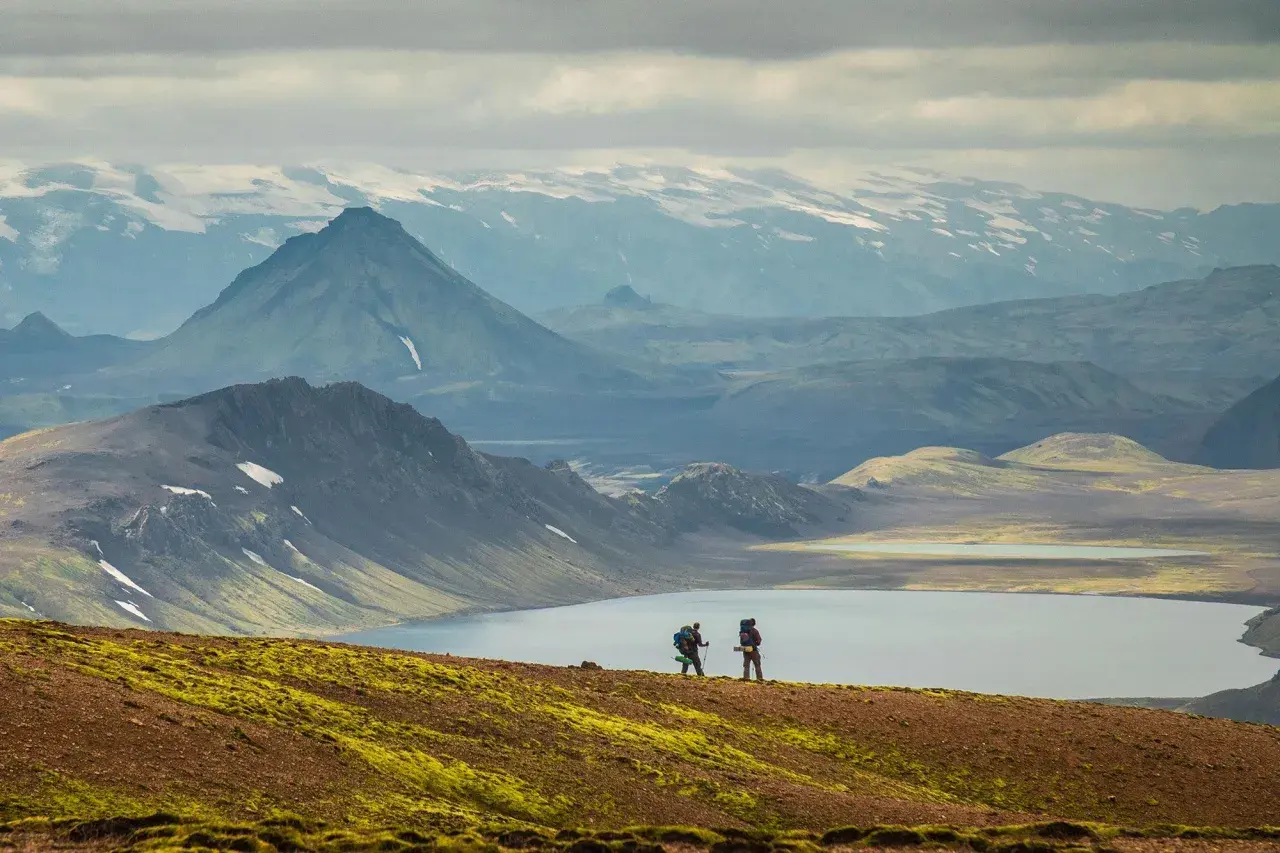
Independent hiking on this trail is completely normal, and that is part of its appeal. The route is well marked, there is enough traffic to make navigation straightforward in good conditions, and the hut system gives you a clear daily structure. But I would not describe it as a casual walk in the park. The highlands change quickly, visibility can collapse in fog, and the terrain can shift from rhyolite hills to snow, black sand, and river valleys in the space of a few hours.
In practice, the self-guided version suits hikers who are comfortable making decisions on the fly. You do not need mountaineering skills, but you do need good judgment, decent fitness, and a realistic attitude about weather. If you like to stay flexible, carry your own gear responsibly, and accept that a schedule may need to change, this is a very manageable independent trip. If you want someone else to handle all timing and safety calls, a guided option may be the better fit.
| Option | Best for | Main trade-off |
|---|---|---|
| Self-guided | Confident hikers who want flexibility and control | You handle booking, weather decisions, and pacing |
| Guided | First-time Iceland highlands travelers or anyone who prefers less logistics | Less freedom and usually a higher overall cost |
My rule is simple: if you are comfortable carrying food, following route markers, and adjusting plans when conditions change, self-guided makes sense. Once that decision is made, the next question is how to pace the route without turning a beautiful hike into a grind.
How to pace the route without rushing it
The standard rhythm is four hiking days, and that is the version I would choose first unless you already know you like long, sustained days. It gives you time to enjoy the landscape instead of just surviving the distance. Strong hikers can compress the route into three days, and very fit hikers sometimes do it in two, but those shorter plans are much less forgiving if the weather turns bad or your legs are not fresh.
| Itinerary | Daily stages | Who it suits | Why it works or fails |
|---|---|---|---|
| 4 days | 12 km, 12 km, 17 km, 15 km | Most independent hikers | Best balance of effort, scenery, and recovery |
| 3 days | 24 km, 17 km, 15 km | Experienced hikers with a strong mountain pace | Efficient, but the first day is a long push |
| 2 days | 28 km, 28 km | Very fit hikers who are comfortable with long days | Fast and demanding; less room for bad weather or fatigue |
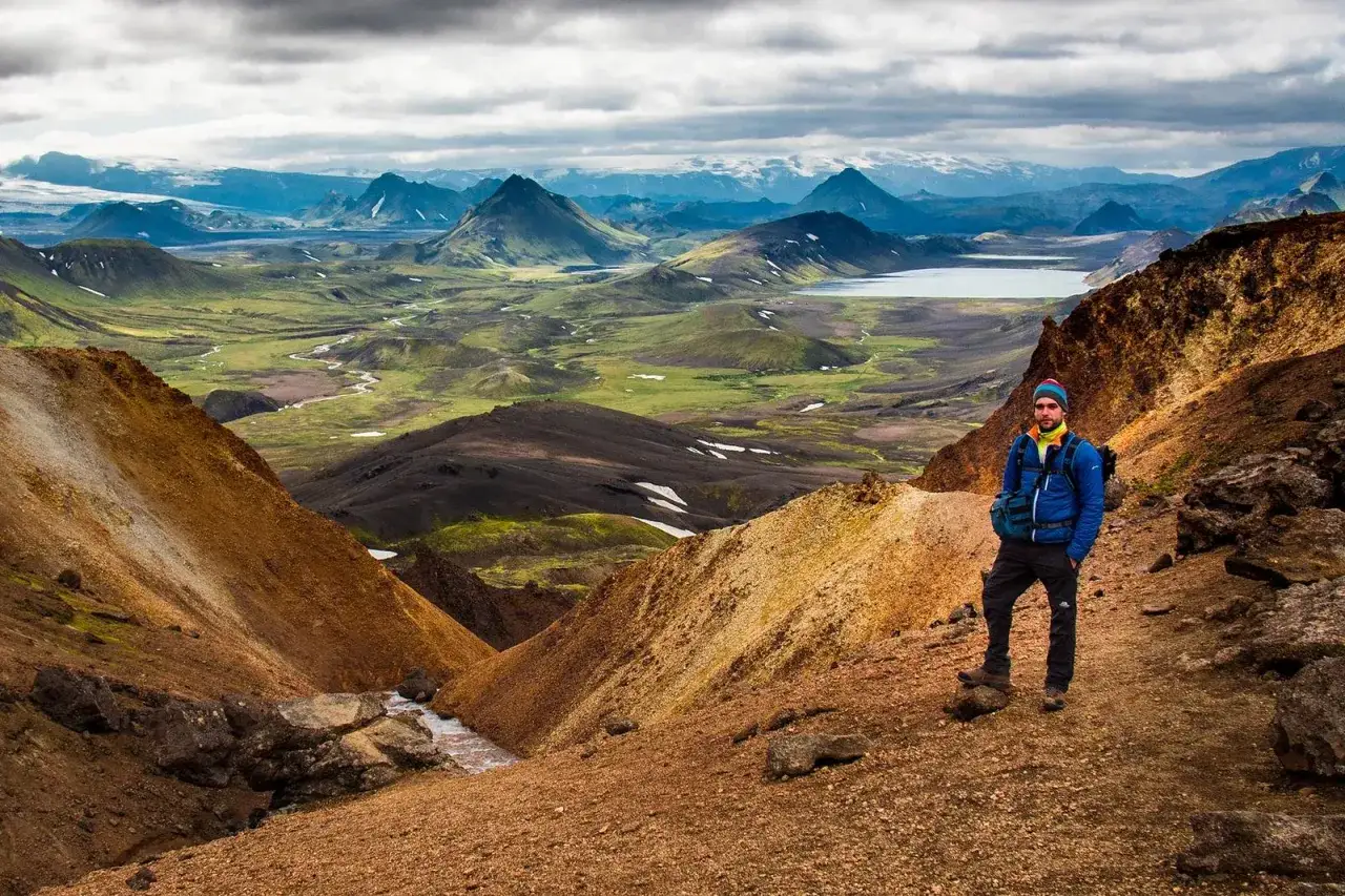
The classic four-day sequence is Landmannalaugar to Hrafntinnusker, then Álftavatn, Emstrur, and finally Þórsmörk. That is the version I recommend for most people because it respects the terrain instead of trying to overpower it. If you want to extend the trip, the Fimmvörðuháls crossing to Skógar adds a serious but rewarding finish, turning the hike into a much bigger Iceland traverse.
For most visitors coming from the United States, the safest planning mindset is to treat this as a point-to-point mountain journey, not a scenic loop. You are not just choosing how far to walk each day; you are also choosing where to sleep, how to leave the Highlands, and whether you want any margin for weather delays. That leads straight into the logistics, which are more important here than on many other famous hikes.
Where to sleep and how to get to the trailhead
Accommodations on the trail are basic, limited, and in high demand. Ferðafélag Íslands expects hikers to have confirmed bookings for huts or campsites before starting, and I agree with that approach. If you leave bookings too late, you may end up forced into a pace or sleeping setup that does not suit you.
Huts are the simplest option if you want lighter packs and more comfort. They are dorm-style, with shared kitchens and bathrooms, and they give you a much easier logistics chain. Camping is possible by all the huts, but it is not a free-form backcountry setup. You still camp in designated areas, you need to talk to the warden before pitching the tent, and campers do not get to use the hut kitchens. You do, however, keep access to bathrooms and drinking water.
- Book your huts or campsites first, then lock in flights and transport.
- Decide early whether you want a hut-to-hut pack or a heavier camping setup.
- Plan your exit from Þórsmörk before you start hiking, not after you finish.
- If you want to extend to Skógar, decide that before you build the rest of the itinerary.
Getting to Landmannalaugar is usually easier by bus from Reykjavík than by self-driving. If you do drive, you need a 4x4 that is authorized for F-roads, and you should check current road conditions before leaving. For many hikers, the bus is the cleanest solution because it avoids highland driving stress and makes the point-to-point nature of the trail much simpler.
Landmannalaugar is also where peak-season traffic and parking rules can become a factor, so I would never assume the access routine will be the same every summer. The broader point is this: in the Highlands, transport is not a side detail. It is part of the hike itself, and it deserves the same attention as your daily mileage.
Gear, weather, and river crossings
Weather changes the plan faster than the map does
The summer weather window is modest by normal travel standards. Daytime temperatures usually sit around 5°C to 14°C, while nights can drop to roughly 0°C to 10°C. Rain is common, wind matters a lot, and anything above about 10-12 m/s starts to feel genuinely difficult on exposed sections. Early summer can still bring snow in the higher, foggier parts of the route, which is why the first two stages demand extra attention.
That is also why I like to leave room in the schedule. If you plan the trail as if every day will be clear and calm, you are setting yourself up for frustration. A flexible mindset is more useful than a perfect forecast.
What I would carry
The pack should reflect the fact that this is a remote mountain route, not a city-to-city trek. For hut-to-hut hiking, a 50-60L backpack is usually enough. If you are camping, you may need 60-70L because the tent, sleeping system, stove, and food all add up quickly. I would not try to save weight by cutting the wrong items, especially layers and rain protection.- Waterproof outer layers and a warm insulating mid-layer
- Sturdy waterproof boots
- Hat, gloves, and a neck gaiter
- River crossing shoes or quick-drying sandals
- Dry bags for clothing and electronics
- Map, compass, and GPS device
- First-aid kit and blister care
- Headlamp, snacks, and enough food for the whole day
Hiking poles are worth carrying if you already use them. They are not mandatory, but they make river approaches and uneven ground easier to manage, especially when your legs are tired.
Read Also: Nocelle Kiosk - Path of the Gods: Maximize Your Hike Stop
River crossings and navigation deserve respect
The trail has a mix of footbridges and wading crossings, and at least three rivers usually need to be crossed on foot. These crossings are generally manageable, but they can rise quickly after rain. I am conservative here: if a river looks unstable, I do not treat the schedule as more important than the crossing. The trail is worth finishing; forcing a bad river decision is not.
Navigation is usually straightforward in normal weather, but fog changes the equation fast. The section from Landmannalaugar up toward Hrafntinnusker and then down toward Álftavatn is especially prone to poor visibility, so I would keep the markers in view and avoid drifting into a casual pace when the weather closes in. There is also no reliable Wi-Fi on the trail, and phone signal can be patchy or absent in parts of the route.
I keep the Safetravel app installed because it can share GPS location with emergency services, which matters more in remote terrain than in almost any other kind of travel. That is not because the hike is unsafe by default; it is because the Highlands reward preparation and punish overconfidence. With the right habits, the route is very manageable. Without them, even a good plan can unravel quickly.
The mistakes that cost energy and calm
Most bad Laugavegur experiences do not come from one dramatic error. They come from several small ones stacking up. The hikers who struggle usually did not fail because they were incapable; they failed because they underestimated how much the trail asks of them before the first boot even touches the ground.
- Booking too late - huts and good campsites disappear quickly in peak season.
- Choosing the wrong pace - the 2-day plan is a fitness test, not a default choice.
- Overpacking or underpacking - both are expensive in a place where the weather can swing hard.
- Trusting the forecast too much - mountain weather in Iceland changes fast enough to make rigid plans look silly.
- Assuming phone coverage will save the day - it often will not.
- Driving without checking F-road conditions - self-driving is possible, but only if you respect the access rules.
If I had to pick the single most common planning mistake, it would be treating the trail like a standard marked trek instead of a remote highland route with real logistics. The map can look simple; the environment is not. The people who enjoy the hike most are usually the ones who plan boringly and hike happily.
The version I would choose for 2026
If I were organizing this trip now, I would keep the formula simple. I would aim for the four-day route, book hut or campsite space before locking in anything else, and use buses rather than self-driving unless I specifically wanted the extra complexity. I would also choose the most stable part of the season, which usually means July or August, because the trail and road access tend to be more predictable then.
I would build one extra cushion into the trip, even if it is just a buffer night in Reykjavík before and after the hike. That small choice makes the whole experience calmer. It absorbs transport delays, lets your body recover, and gives you a better chance to enjoy Þórsmörk instead of rushing through it.
The independent version of the Laugavegur hike is not about proving anything. It works best when you respect the weather, keep the pack sensible, and let the route set the pace. If you do that, the trail gives you one of the cleanest self-guided Highland experiences in Iceland, and the memory stays with you long after your boots dry out.