On a hiking route, the difference between a relaxed day and a bad decision often comes down to whether you can read the ground before you step onto it. That is why topographic maps are useful: they show elevation, slope, valleys, ridges, water, and man-made features in a way a simple trail brochure usually cannot. In the United States, that extra detail matters just as much on signed park trails as it does on long backcountry routes, because terrain changes how far a hike feels, how hard it climbs, and where it becomes risky.
What you gain from a topo map
- You can see steep climbs, gentle grades, and hidden elevation changes before you start hiking.
- You can plan safer routes by spotting ridges, drainages, water crossings, and bailout options.
- You can navigate more confidently in places with weak cell service, sparse signage, or complex terrain.
- You can compare a paper map, a GPS app, and a trail brochure instead of relying on only one tool.
- You can avoid common mistakes like ignoring contour spacing, scale, and elevation gain.
They reveal the shape of the land
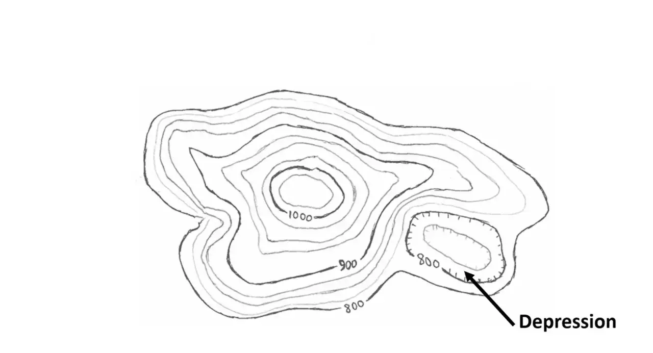
A topographic map does not just tell you where the trail goes. It shows how the ground rises and falls along the way. The contour lines connect points of equal elevation, so when those lines bunch together I know the slope is steep, and when they spread apart I expect easier walking. A tight cluster of contours around a trail often means a short route can still feel brutally demanding.
Contour lines are the language of terrain
Once you understand contour lines, features such as ridges, valleys, saddles, spurs, and drainages stop being abstract. A ridge usually appears as high ground stretching out from a summit, while a valley or drainage cuts downward toward lower terrain. A saddle is the low spot between two higher points, and it often becomes the simplest place to cross a ridge line. Those shapes matter because they tell me how water, wind, exposure, and effort are likely to behave on the ground.
Read Also: Fishermen's Trail Map - Plan Your Perfect Portugal Hike
Spacing tells you how the hike will feel
I pay attention to contour spacing before I ever look at mileage. A trail that covers three miles but climbs steadily through closely packed contours may feel tougher than a five-mile route with a gradual grade. That single habit saves a lot of beginner frustration, because distance alone rarely describes the real work of a hike. Once the land makes sense, route choice starts making sense too.
They help me choose a safer route
When I plan a hike, I want more than a destination. I want to know where the hardest climb is, which side of a ridge is more exposed, where water crosses the trail, and whether there is a realistic bailout if weather turns. A topographic map makes those decisions visible before I commit to them. It is one thing to say a trail is moderate; it is another to see that the route gains 1,200 feet in a little over a mile and crosses a steep drainage before the final ridge.
- Long, steady climbs that look short on a mileage chart
- Stream crossings that may flood, disappear, or slow you down
- Ridges and open slopes where wind and exposure become a real factor
- Alternate exits if weather, fatigue, or daylight become a problem
- Sections where navigation will be harder than the trail distance suggests
That is why I think of a topo map as a risk-reduction tool first and a navigation tool second. The more difficult or remote the country, the more that matters. And once risk is visible, the next question is which kinds of places benefit most from that detail.
They matter most where trail signs stop helping
On a well-marked day hike, a simple trail brochure may be enough. The deeper value of a topo map shows up when the route becomes less obvious: forest service roads, alpine basins, desert washes, broken ridge systems, and wilderness areas where signs are sparse or distances are deceptive. In those places, the map is not just a nice extra. It is often the difference between staying on a logical line and wandering into terrain that looks manageable until you are already in it.
| Map type | What it does well | Where it falls short | Best use |
|---|---|---|---|
| Topographic map | Shows elevation, slope, drainage, and landform shape | Needs some practice to read quickly | Route planning, off-trail travel, backups |
| GPS hiking app | Shows your live position and tracks progress | Depends on battery and device reliability | Confirmation and tracking |
| Trail brochure map | Gives a clean overview of signed routes and facilities | Too generalized for nuanced route decisions | Short, maintained day hikes |
I usually combine them instead of choosing one. The topo map tells me what the land will demand, the GPS app tells me where I am, and the brochure map gives me a quick overview of the park or trail system. That combination is especially useful when the route crosses more than one type of terrain.
They stay useful when the phone does not
A phone app is helpful, but it is still a battery-powered screen. Cold weather shortens battery life, glare makes the display harder to read, rain forces extra caution, and a dead zone can leave you with a frozen blue dot and too much confidence. A paper topo map does not solve every problem, but it keeps working when service, battery, or app behavior becomes unreliable.
There is one limitation I never forget: a map cannot show live conditions. It will not warn you about a washed-out bridge, fresh snow, a closed trail, or a river running higher than normal. That is why I treat topo maps as the structural layer of planning, not the final word on conditions. They give me the shape of the route; they do not give me the day’s mood.
That matters most in remote parks and wilderness areas, where offline maps are useful but should still be backed by a paper copy. In practice, I want both: a downloaded map for convenience and a printed topo map for the moments when the device stops being trustworthy. The backup is not old-fashioned; it is simply cheaper than getting turned around.
The mistakes that trip hikers up
Most topo-map mistakes are not dramatic. They are small reading errors that pile up.
- Ignoring contour interval and assuming every tight cluster means the same grade
- Looking at mileage and forgetting elevation gain
- Not orienting the map to the terrain before starting
- Missing scale and underestimating how long a cross-country section will take
- Forgetting that a route can be passable on paper and messy in real life because of snow, blowdown, or seasonal water
- Not accounting for magnetic declination, which is the difference between map north and magnetic north when using a compass
The common thread is overconfidence. A topo map is precise, but it is still a model of the terrain, not the terrain itself. Treating it that way keeps you accurate without becoming rigid. The goal is not to worship the map; it is to use it well enough that surprises become manageable.
How I use one before leaving the trailhead
Before a hike, I spend a few minutes turning the map into decisions. That prep is usually enough to prevent the most avoidable mistakes later.
- Trace the start, finish, and any bailout points.
- Find the highest point, lowest point, and biggest climb.
- Mark water crossings, ridgelines, and obvious route junctions.
- Estimate how steep the trail feels, not just how long it is.
- Load an offline copy on my phone and carry a paper backup if the route is remote.
- Use a compass if the route leaves marked trail or crosses featureless ground.
I also make a habit of checking whether the map is the right scale for the trip. For a long backcountry route, a detailed map is worth carrying even if it means a little more weight, because the detail often saves far more time than it costs. Once the plan is set, the real question is whether the map still adds value after the hike starts.
The real payoff is less guesswork on rough ground
The real value of a topographic map is not that it looks technical. It is that it turns terrain into information I can use before, during, and after a hike. It helps me judge effort, spot hazards, choose smarter alternatives, and stay oriented when the path is not obvious.
If I had to give one simple rule, it would be this: use a topo map to understand the land, use GPS to confirm position, and use your own eyes to settle any disagreement. When those three agree, I move with far more confidence. When they do not, I slow down, recheck the route, and question the easy assumption.
That habit matters everywhere from weekend trails to remote mountain basins, and it is one of the most useful skills a hiker can carry without adding much weight to a pack.