The key facts that shape a realistic plan
- Distance: about 230 miles / 370 km from Fort William to Cape Wrath.
- Time: most walkers allow 16 to 22 days, depending on route choice, weather, and pace.
- Navigation: it is unmarked, with no single official line, so map and compass skills matter every day.
- Support: resupply is limited, and most hikers carry a tent rather than relying on accommodation.
- Best window: late spring through early autumn usually offers the most workable balance of daylight and conditions.
- Biggest payoff: the final approach via Sandwood Bay and into Cape Wrath is one of the strongest finishes in British long-distance walking.
What this route actually is
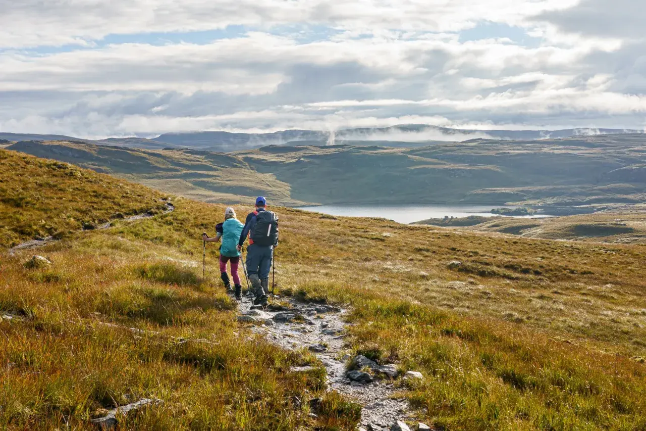
This is a remote Highland backpacking route from Fort William to Cape Wrath, the northwesternmost point of mainland Scotland. It threads through some of the wildest country in the country, including areas around Morar, Knoydart, Torridon, and Assynt, and it is better understood as a flexible expedition than as a single fixed path.
That flexibility is part of the charm. There is no single painted line to follow, which means walkers choose between common variants and local alternatives depending on terrain, confidence, and conditions. I would not describe it as a “walk and enjoy the views” kind of trip; I would describe it as a trip where the views are the reward for making good decisions for days on end. That leads straight into the question most hikers ask next: what actually makes it so hard?
Why this walk is so demanding
The trail’s difficulty comes from several things at once. The ground is rough and often boggy, the route is unmarked, river crossings can become serious after rain, and services are sparse enough that self-reliance is not optional. Add changeable weather, ticks, midges, and long days under a loaded pack, and you get a route that demands consistency more than speed.
| Challenge | What it means on the ground | How I would handle it |
|---|---|---|
| Navigation | No waymarking and no single official line, so route-finding is part of the day. | Carry paper maps, a compass, and a GPX track, and know how to use all three. |
| River crossings | Heavy rain can turn a normal crossing into a real risk. | Build in time buffers and be willing to wait rather than force a crossing. |
| Terrain | Bogs, rough moorland, and pathless stretches slow progress more than mileage suggests. | Plan shorter daily distances than you would on a maintained trail. |
| Self-sufficiency | Food, fuel, and shelter need to last between limited resupply points. | Assume you will carry several days of food and a proper camping setup. |
| Weather | Wind and rain can change the feel of a section in an hour. | Pack for comfort in poor weather, not just for the best forecast. |
If you are already comfortable on long, remote backpacking routes, the challenge is manageable; if you are not, this is not the place to learn by improvisation. That is why route choice matters so much, because the line you choose can make the first half feel quite different from the last.
How to choose your line through the Highlands
Most walkers go south to north, and I think that is the right call for first-time finishers. The route builds naturally toward Cape Wrath, and the approach across Sandwood Bay gives the trip a memorable ending rather than an abrupt one. Walking north to south is possible, but you lose some of that sense of crescendo.
| Route line | How it feels | Best for | Tradeoff |
|---|---|---|---|
| Via Glenfinnan | More immediately dramatic and often feels wilder from the start. | Hikers who want a classic west-coast opening and do not mind a committing feel early on. | It can feel more exposed emotionally and logistically in the opening days. |
| Via the Great Glen | Slightly more structured at the beginning, with a route that can feel easier to settle into. | Walkers who want a gentler ramp-in before the country gets truly remote. | It may feel less immediately wild than the Glenfinnan approach. |
The trail is also commonly broken into three big blocks: Fort William to Strathcarron, roughly 147.4 km and usually 7 to 9 days; Strathcarron to Inverlael, about 80 km and 3 to 4 days; and Inverlael to Cape Wrath, about 142 km and 6 to 9 days. Those numbers are useful because they show the real issue: this is not one long day after another, but a chain of demanding decisions, and that naturally raises the question of timing.
When to go and what the season changes
The most practical window is usually May to September. That period gives you the best mix of daylight, temperatures, and operational logistics at the Cape Wrath end of the route. Even then, the northwest Highlands stay honest: a good forecast can become a wet one quickly, and river levels can change after a single storm.
- Late spring: Long daylight and cooler temperatures, but nights can still feel cold and midges are not yet the only nuisance.
- Summer: The most forgiving balance overall, especially for hiking pace and comfort, though it can still be wet and windy.
- Early autumn: Often quieter and visually excellent, but daylight starts to shrink and weather windows get tighter.
- Shoulder season: Only for very confident walkers who are comfortable adjusting plans fast.
I would plan around weather, not around ambition. If a route section depends on a safe river crossing or a specific transport connection at the finish, that is not a detail to “sort out later.” It is the trip. Once season is chosen well, the next thing that matters is gear, because the trail punishes optimistic packing.
Gear and navigation that matter most
The gear list does not need to be flashy, but it does need to be disciplined. On a trail like this, lighter is better only if it still leaves you warm, dry, and able to think clearly after a bad day. In practical terms, that means a pack that is genuinely comfortable under load, a tent that handles wind and rain, and navigation tools that do not depend on one battery or one app.
- Navigation: Paper maps, compass, and a GPX track on a phone or GPS device. GPX simply means a digital route file you can follow on the trail.
- Shelter: A sturdy 3-season tent is the default choice, because most walkers camp and the weather can turn quickly.
- Clothing: Waterproof shell, insulating midlayer, hat, gloves, and a midge head net. If you only bring one luxury, make it comfort in bad weather.
- Food and water: Enough capacity for several days of food and a reliable water filter. A filter lets you treat stream water without carrying huge volumes.
- Safety kit: Blister care, basic first aid, repair tape, and a headtorch with spare power.
Resupply, accommodation and getting off the trail
Food planning is one of the trail’s real puzzles. Services are limited, villages are widely spaced, and the majority of walkers either camp most nights or mix camping with occasional hostels, bothies, and small stays where available. A bothy is a basic unlocked shelter, usually very simple, that can be invaluable in bad weather but should never be treated like guaranteed accommodation.
If you want to keep the pack manageable, parcel drops are often the cleanest solution. A parcel drop is simply food or gear mailed ahead to a point on the route, which reduces how much you carry at any one time. I would use them for dense, boring calories rather than for “nice to have” extras; this is not the trail for gourmet packing.
- Plan for 3 to 4 days of food at a time unless you have confirmed a resupply point.
- Treat accommodation as optional, not as the backbone of the itinerary.
- Build a buffer into your finish, because the Cape Wrath access side is seasonal and weather-sensitive.
- Assume transport may be the fragile part of the whole trip, especially if you need to connect onward the same day.
The end of the trail also deserves special respect. Cape Wrath itself is not a place you should assume you can access on your preferred schedule without checking conditions, because military activity and seasonal transport can affect the final move in or out. That is why the smartest finish plans are the simple ones: don’t schedule a tight onward journey, and don’t build the whole trip around a perfect same-day connection. With the logistics handled honestly, the last section becomes what it should be, which is a long, memorable approach rather than a stress test.
What I would lock in before setting off
If I were planning this route, I would make four decisions before leaving home: the exact line I wanted to follow, the places where I would resupply, the gear I refused to compromise on, and how much flexibility I had at the finish. Those choices matter more than shaving half a mile off a daily distance target.
- Choose one route line and commit to it unless river levels or weather force a change.
- Build two or three resupply points into the plan instead of hoping shops will solve the problem.
- Carry the right navigation tools rather than relying on the route to feel obvious in poor visibility.
- Leave one buffer day if your onward travel matters, because the finish is the least flexible part of the trip.
That is the real shape of the trail: remote enough to reward preparation, varied enough to stay interesting, and serious enough that every easy shortcut gets punished later. If you prepare for the conditions honestly, the route gives back something rare in modern hiking: a genuine sense that you have crossed a difficult stretch of Scotland on your own terms.